Support
Understanding Technical Terms
Understanding Technical Terms
A glossary to help understand some of the common technical terms associated with aerial photography.
| Glossary of Terms | |
|---|---|
| Acetate base | A transparent plastic film which is coated with a photographic emulsion. It is composed of cellulose acetate and is practically non-flammable. |
| Aerial film | A specially designed roll film supplied in many lengths and widths to fit aerial cameras. Emulsion types include panchromatic, infrared and colour. |
| Aerial photography | Any photograph taken from the air - sometimes called an air photograph. |
| Aerial reconnaissance | The securing of information by aerial photography or visual observation from the air. |
| Air intelligence | Military intelligence directly concerning air activities of the enemy, weather, order of battle, anti-aircraft defences, airdromes and target information. |
| Altitude | Height above a datum. The datum is usually mean sea level. |
| Altitude (absolute) | Height above the surface of the earth as differentiated from altitude - height above sea level. |
| Anaglyph | An image used to provide a stereoscopic 3D effect when viewed with 2 colour glasses (often cyan / red). Images are made up of two colour layers, superimposed, but offset to produce a depth effect. |
| Classification | A category or grade that is assigned to information or material which denotes the degree of danger to national security which would result from its unauthorised disclosure. The security classification establishes a standard of care in the handling, storage and dissemination of classified matter. |
| Contact print | A print made from a negative or a diapositive in direct contact with sensitized material. |
| Coverage | The ground area represented on aerial photographs / photomaps / mosaics / maps etc. |
| Diapositive | A positive photographic image on a transparent medium. |
| Emulsion | A suspension of a light-sensitive silver salt, usually silver chloride or silver bromide in a gelatin medium, used for coating photographic films, plates or paper. |
| Fiducial marks | Index marks, located in the corners or edge-centres of an aerial photograph, rigidly connected with the camera lens through the camera body. They are used to define the frame of reference for spatial measurements in photogrammetry. |
| Film | A thin, flexible, transparent sheet coated with light-sensitive emulsion, for use in the camera. |
| Film base | A thin, flexible, transparent plastic sheet of cellulose nitrate, acetate or similar material which is coated with a light-sensitive emulsion and used for taking photographs. |
| Finding aid | See 'Plot'. |
| Flight line | The flying path an aircraft took when taking photographs during a sortie. |
| Flying height | The height at which the aircraft was flying when photographs were taken - this has a direct effect on the photograph scale. |
| Focal length | This is the size of the lens on the aerial camera and has a direct effect on the nominal scale of an aerial photograph - the smaller the lens the smaller the scale. |
| Gain | This is measured in area (eg. sq km) and is the amount of ground an aerial photograph covers which is not covered by the previous or adjacent photograph in the run. It can also be measured as a percentage |
| Georectification | A method of digitally rectifying aerial imagery in such a way that it is map accurate. |
| GIS - Geographical Information Systems | A computer system for the input, storage, retrieval, analysis and display of geo-spatially referenced data. The data is typically stored as a series of layers. |
| Imagery analysis | The use of satellite and aerial imagery, geospatial data, full motion video and other electronic monitoring in order to collect and analyse information required to design plans, support combat operations and disaster relief. The modern name for Photographic Interpretation (see 'Photographic interpretation'). |
| Imagery Analyst (IA) | The name for someone who undertakes Imagery Analysis tasks - typically within a military environment. The modern name for a Photographic interpreter (see 'Photographic interpreter'). |
| Infrared film | Film carrying an emulsion especially sensitive to infrared and blue light. Used to photograph through haze, because of the penetrating power of infrared light, and in camouflage detection to distinguish between living vegetation with chlorophyll and dead vegetation or artificial pigment. |
| Joint Air Reconnaissance Intelligence Centre (JARIC) | Until 2013, the key agency responsible for providing the British Government with geospatial intelligence, from aerial imagery and other sources, in support of defence and national interests. Now subsumed within the Defence Intelligence Fusion Centre (DIFC). The majority of imagery in NCAP was declassified and released by JARIC. |
| Mission | The dispatching of one or more aircraft to accomplish one particular task. Most commonly used by US Air Force, whereas 'sortie' is used in the UK by the Royal Air Force. See 'Sortie'. |
| Mosaic | The process of seamlessly joining several images together to form one large image. Traditionally this involved cutting and splicing contact prints together and photographing this assemblage. The mosaic negative would then be used to print enlargements. |
| Nitrate base | Cellulose nitrate - a highly flammable plastic used as a base for some aerial films. |
| Oblique photography | An aerial photograph taken with the camera pointing in a slanting direction towards the ground. For more information, see the News Article on Vertical, Oblique and Ground Aerial Photography |
| Oblique photograph - high | An oblique photograph in which the horizon is shown. See an example oblique aerial image where horizon is shown. |
| Oblique photograph - low | An oblique photograph in which the horizon is not shown. See an example oblique aerial image where the horizon is not shown. |
| Orthophoto | An aerial photograph which has been orthorectified, to combine the image characteristics of a photograph with the geometric qualities of a map. |
| Orthorectification | The process of rectifying a digital aerial photograph in such a way that terrain induced distortions are removed and all ground features are in their true planimetric position. |
| Overlap | In aerial photographic terms, this is the amount of overlap between two adjacent photographs. There are established standards that describe the amount of overlap required to view in stereo. This is typically 60% forward and 15% laterally (ie at the top-and-bottom and side-to-side) |
| Photo scale (nominal) | Scale at which a photograph is taken. The scale is a function of the flying height and the focal length of the camera. |
| Photogrammetry | The science of obtaining accurate measurements by means of photography. |
| Photographic intelligence | The collected products of photographic interpretation, classified and evaluated for military use. |
| Photographic interpretation | The utilisation of systems, techniques or processes of analysing photographs which enable the production of reliable and detailed information concerning the natural or cultural features of the area photographed and to determine or infer the factors which the observable presence, condition or use of these features imply. See Imagery Analysis. |
| Photographic interpreter (PI) | The name for someone who undertakes Photographic Interpretation tasks - typically within a military environment. See Imagery Analyst. |
| Photographic reconnaissance (PR) | The obtaining of information by air photography, normally carried out by special aircraft. |
| Photomap | A single photograph, composite or mosaic showing coordinates and adequate marginal information - normally produced in quantity. |
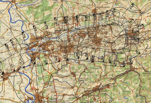
| Plot | A plot of aerial photographs is the outline, drawn on a map, of the area covered by a photograph or strip of photographs. From the plot, and the data on it, it should be possible to identify whether a given area has been covered by photographs during a sortie. The plot should also detail the date / mean-time / scale / quality of photography. |
| Rectification | The general term for the process of positioning an aerial photograph in true geographical space. |
| Resolution | The resolution of an image depends on several factors, including emulsion, atmospheric conditions and lens type. In general, at 1 |
| Roll film | A strip of film wound on a spool. Most aerial film is roll film. Roll film is of many different kinds, sizes and colour sensitivities. |
| Safety film | Film with cellulose acetate base - so called because it burns very slowly in contrast to the highly flammable nitrate base film. |
| Scanning | A data capture technique which digitises information from a film or paper hardcopy into digital raster data. The process is rapid, but the resulting data does not have the 'intelligence' necessary for GIS analysis. |
| Sortie | British, Royal Air Force aircraft flight, task or mission. US Air Force use the term 'mission' to mean the same. These terms can be used interchangeably; commonly 'sorties' will refer to British flights and 'mission' used alongside US flights. |
| Stereo | Shortened form of "stereoscopic". Photographs properly oriented for stereoscopic viewing are said to be "in stereo". |
| Stereoscope | A binocular optical instrument used to view two properly oriented photographs, with sufficient overlap and consequent duplication of detail, to obtain the mental impression of a three-dimensional model. |
| Stereoscopic | Of or relating to stereoscopy. |
| Stereoscopic pair | Two photographs with sufficient overlap and consequent duplication of detail to make possible stereoscopic examination of an object or area common to both. |
| Stereoscopy | The science which deals with three dimensional effects and the methods by which these effects are produced. |
| Strike photography | Photography taken during an air attack. |
| Strip reconnaissance | A series of overlapping aerial photographs which, when joined together, provide a continuous picture of the area photographed. A reconnaissance strip is generally used in studying a long narrow piece of terrain such as a river or a road. |
| Survey photography | An aerial photograph taken specifically for the purposes of ground survey. |
| Target analysis | The examination of potential targets to determine their military importance, their relative priority for attack, and the capabilities of available means for such attack. |
| Tilting strip | The information lettered on photographic negatives in accordance with regulations. Supplementary information was often added for special purposes. The information was placed so as not to obscure the photographic image. |
| Transparency | A positive image on a clear base, which must be viewed by transmitted light - see diapositive. |
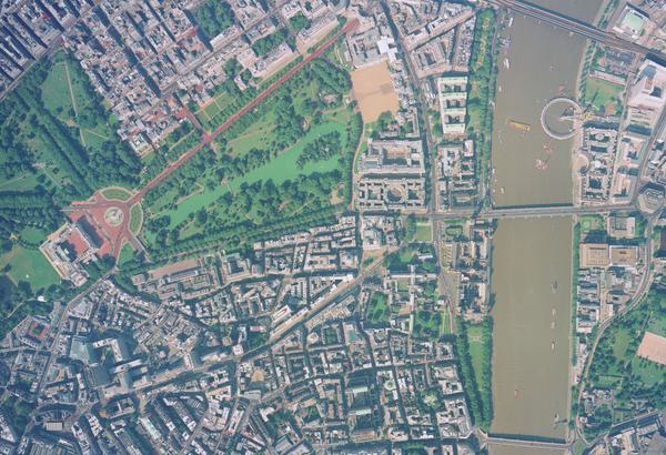
| Vertical Photograph | An aerial photograph taken with a camera looking directly down from the bottom of an aircraft. The photograph gives a plan view of the ground and is therefore easy to compare with a map. For more information, please see our Feature on Vertical and Oblique Aerial Photography |
IN THIS SECTION

Case Studies
Explore the many new ways historical aerial imagery is being used today.

How-To Guides
Use the step by step guides to help you navigate some of the key tools from the NCAP archive.

FAQs
Find answers to some of the most common questions asked of the NCAP team.

Contact Us
Find the best ways to get in touch with the team at NCAP for research support, project partnerships or image sales.

Subscriptions
Subscriptions allow you to zoom images on the website and access finding aids to help identify images.

Newsletter
Sign up to our newsletter to start receiving regular email news updates about NCAP.

Online Sources of Aerial Photography
As well as NCAP, here are some other places you can go for aerial photos and information.